Cape of Good Hope Overnight Trail: Permits, Huts and a Two-Day Coastal Route
Everything you need to plan Cape Town’s most coastal overnighter: how to book with SANParks, what the huts offer, distances and elevation, what to pack, and when to go.
Why this overnight ranks among Cape Town’s best
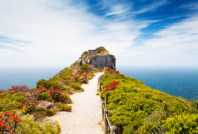
Few hikes stitch together ocean cliffs, wild beaches, milkwood thickets and fynbos-covered kopjes quite like the Cape of Good Hope Overnight Trail. This two-day, one-night circuit explores the Cape Point section of Table Mountain National Park, with nonstop Atlantic and False Bay vistas and regular wildlife sightings. It’s a managed SANParks trail with rustic hilltop huts, clear waymarking, and secure overnight parking at the entrance—perfect for adventurous travellers who want a big experience without carrying a tent.
Before you lace up, here’s a complete, practical guide covering bookings, distances and elevation, hut facilities, packing, and the season-by-season weather you’ll meet on the Cape of Storms.
• Trail format: 2 days, 1 night, circular route
• Total distance: about 33.8 km
• Typical time: Day 1 (5–7 hours), Day 2 (8–10 hours)
• Elevation: rolling terrain with several steady climbs; expect roughly 800–1,000 m cumulative gain across both days depending on detours
• Overnight: two simple huts on a hilltop inside the reserve
How SANParks bookings and permits work
The route lies inside the Cape of Good Hope (Cape Point) section of Table Mountain National Park and is administered by SANParks. You don’t just “show up and walk”—you must reserve a spot on the overnight trail and settle conservation fees.
What you book and pay
• Overnight trail reservation: secures bunks in the hilltop huts for one night on your chosen date.
• Daily conservation fees: payable per person for each day you enter the reserve (waived/reduced with a valid Wild Card). These are separate from your hut fee.
How to book
Check availability with SANParks for the Cape of Good Hope Overnight Trail (Table Mountain National Park). Weekends and school holidays fill quickly—plan well ahead.
Reserve and pay for your party. Confirm names and ID numbers for all hikers; age limits and group-size caps apply and solo hikers are generally not accepted.
Receive your booking confirmation/permit details. Save them offline.
On the day: arrive at the main entrance gate at opening time (08:00). Collect the hut key from the Access Control Officer, complete the Overnight Hiking Register, and park in the designated secure area for overnighters. You should be on the trail by 09:00 to comfortably reach the huts before dark.
On departure: sign the register again and return the hut key at the gate.
Good to know
• The overnight register is compulsory—you’ll sign in at the start and out at the end.
• The gate opens at 08:00; arrivals earlier than this are not permitted.
• You’ll be asked to depart the huts by around 09:00 on Day 2 to ensure you finish in daylight.
• If the forecast looks dangerous (severe wind or heavy fronts), call ahead—SANParks may advise postponement. Standard change/cancellation terms apply to your booking.
Distances, times and elevation at a glance
• Day 1: roughly 13–14 km, 5–7 hours. The day builds gradually from coastal paths on the False Bay side into a series of undulating climbs through fynbos and over low saddles, ending with a final push to the hilltop huts. Expect a cumulative gain of 350–500 m, with little shade midday.
• Day 2: about 20.5 km, 8–10 hours. You’ll leave the huts by 09:00, briefly touch a tarred road to cross the main reserve road, then follow well-marked singletrack to Pegram’s Point. From here the path hugs the Atlantic shoreline past long beaches and rocky bays (including Platboom), before turning inland through milkwood thickets and restio fields to complete the loop back to the entrance. Beach and soft-sand sections slow the pace; cumulative gain is moderate but steady.
Surfaces alternate between firm singletrack, sandy beach, rocky steps and a few short tar connectors. The route is well waymarked with painted footprints at key junctions, but fog and wind can reduce visibility—carry a map or GPX and know how to use it.
Hut facilities: what to expect (and not to)…