Cape Point vs Cape of Good Hope: The Difference and the Perfect Day-Trip Loop
Still mixing up Cape Point and the Cape of Good Hope? Here’s how they differ, where the lighthouses and viewpoints are, current fees, and a smooth loop from Cape Town with time checks.
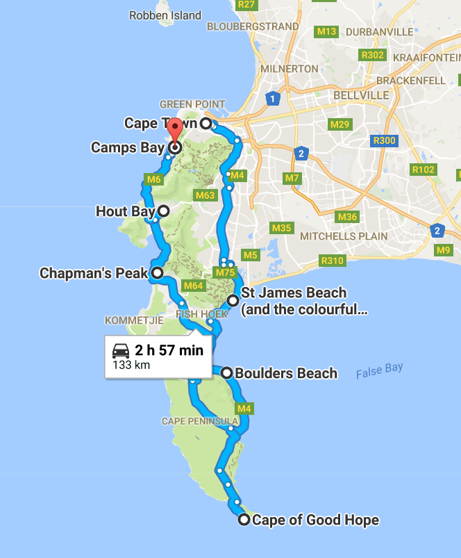
Why these two capes get confused
Cape Point and the Cape of Good Hope sit inside the same section of Table Mountain National Park, but they’re not the same place.
- Cape Point: The dramatic south‑eastern corner of the peninsula, crowned by a historic lighthouse. Think sheer cliffs above False Bay and big panoramic views.
- Cape of Good Hope: The most south‑western point of Africa, set a short drive/walk west of Cape Point with the famous wooden sign on a wave‑washed rocky shore.
Key fact: The “two oceans meet” point is actually at Cape Agulhas, two hours east of Cape Town. You’ll still see powerful currents and contrasting seas here, but Agulhas is the true divide.
Distance between the two: roughly 2.3 km as the cormorant flies. A gorgeous cliff‑top path links them; otherwise it’s a few minutes by car between the two parking areas.
What’s where: lighthouses, trails and viewpoints
Use this quick mental map once you’ve passed the main gate (Cape of Good Hope/Cape Point section of Table Mountain National Park):
- Cape Point Parking & Funicular (Flying Dutchman): The transport hub for the lighthouse area, with a small plaza, take‑away and restrooms. The funicular shuttles you part‑way up; you can also walk.
- Old Lighthouse (1860): On the summit directly above the parking. A 10–20 minute uphill walk or funicular + short stair climb. Best for sweeping views over False Bay and the rugged spine of the peninsula.
- New Lighthouse (1919): Built lower down on the cliffs to cut through fog. Reach the viewpoint via the Lighthouse Keeper’s Trail (allow 20–30 minutes return from the summit path). This vantage puts you eye‑level with the sea cliffs.
- Cape of Good Hope Car Park & Sign: Turn right at the signed junction about 10–15 minutes’ drive beyond the gate. Short stroll to the iconic “Most South‑Western Point of the African Continent” sign and boulder‑strewn shoreline.
- Cliff‑Top Boardwalk (Cape of Good Hope Trail): A superb, mostly wooden walkway linking Cape Point to the Cape of Good Hope above booming surf and nesting cormorants. Allow 45–75 minutes one way depending on photos and wind.
- Dias and Da Gama Cross Lookouts: Two stone crosses on the high ridge between False Bay and the Atlantic side; great for wide panoramas and sunset glow.
- Wild beaches and picnic spots: Platboom (wind‑sculpted dunes), Olifantsbos (shipwreck trail), Bordjiesrif (more sheltered, tidal pool). Always watch surf and currents; conditions change fast.
Wildlife notes: You may see ostrich, bontebok, eland and baboons. Keep a car window’s length from animals; never feed baboons and secure food inside your vehicle.
Entry fees, hours and essentials (2026)
- Gate fees: As a guide, international adults are around R450; children about half. South African and SADC residents pay discounted rates with valid ID. Prices change annually—confirm on the SANParks website before you go.
- Payment: Card facilities at the gate are standard; carry a backup card in case of outages.
- Hours: Typically from around 06:00–18:00 in summer and 07:00–17:00 in winter (last entry roughly one hour before closing). Exact times vary by season—double‑check before departure.
- Funicular: Tickets sold at the base station; useful in high winds or for conserving time.
- Food & facilities: There’s a restaurant and a takeaway at Cape Point; restrooms at main nodes. Carry water—there’s little shade.
- Wind and layers: The Cape can whip up quickly; bring a warm layer, hat with chin strap and sturdy shoes.
The smooth loop from Cape Town (with time checks)
This loop balances crowd‑beating timing, great light and minimal backtracking. Distances are approximate; adjust for season and interest.
1) 07:30 – Depart City Bowl/Waterfront
- Route: M3 toward Muizenberg (40–50 minutes with light traffic).
- Quick coffee option: Stop in Kalk Bay or St James along the False Bay coast if you left early.
2) 08:45 – Simon’s Town (optional penguins)
- If penguins are a must, detour to the Boulders boardwalks right at opening for fewer crowds (45–60 minutes). Otherwise, continue—there’s more to see later.
3) 09:45 – Enter the park (Cape of Good Hope/Cape Point gate)
- Drive time from Simon’s Town: ~15 minutes. Have your card and ID ready.
4) 10:05 – Cape Point lighthouse area
- Park, then either walk (10–20 minutes uphill) or take the funicular.
- Summit time: 30–45 minutes for photos, then add 20–30 minutes if you include the New Lighthouse viewpoint via the Lighthouse Keeper’s Trail.
5) 11:30 – Cliff‑top walk to the Cape of Good Hope (or drive)
- If you’re keen to hike: follow the marked boardwalk from near the lighthouse area toward the Cape of Good Hope (45–75 minutes one way). Arrange a lift back or return the same way.
- If you’re short on time: drive 10 minutes to the Cape of Good Hope car park, stroll to the sign and explore the rocks.
6) 12:45 – Picnic or light lunch inside the park
- Choose a sheltered spot such as Bordjiesrif or sit on the lee side of rocks near the Good Hope sign (watch waves). Alternatively, head to the restaurant back at Cape Point.
7) 14:00 – Atlantic coast exit via Misty Cliffs → Noordhoek
- Scenic drive north past Scarborough and Misty Cliffs to Noordhoek (30–40 minutes). Late lunch/coffee near Noordhoek beach.
8) 15:30 – Chapman’s Peak Drive → Hout Bay
- Toll road with pull‑offs for photos (allow 30–45 minutes with stops). Golden afternoon light often arrives here first.
9) 16:30–17:00 – Hout Bay → Sea Point/Waterfront
- Final leg into the city (25–35 minutes). You’ll be back well before dark outside of mid‑winter.
Total time inside the reserve: 3–5 hours is comfortable for the lighthouse, a viewpoint or two, and the Good Hope photo stop. Add another hour if you do the full cliff‑top walk.
Quick answers
- Do I need a 4×4? No—paved roads throughout, with some graded side roads.
- Best light? Morning on False Bay (Cape Point side) and late afternoon on the Atlantic (Good Hope, Misty Cliffs, Chapman’s Peak).
- Can I swim? Only in calm, sheltered spots like Bordjiesrif’s tidal pool. Heed signage; currents and waves are strong.
- Kids and accessibility: The funicular reduces climbing; boardwalk sections have stairs. Prams are easier around the parking areas than on cliff paths.
Stay close for an easy early start
Base yourself near the city and Atlantic seafront for a quick getaway to the M3 and the peninsula.
- Walk‑to‑everything convenience: Walk to the V&A Waterfront from a Charming Apartment is ideal for pre‑dawn departures and post‑drive dinners on the harbour.
- Big‑sky sunsets back in town: If you prefer Table Bay views, consider Postcard Views of Table Mountain. Generator for elevator. in Milnerton—perfect after you return via Chapman’s Peak and the Atlantic seaboard.
With the names demystified, lighthouses located and a loop in your pocket, you can focus on the main event: those wild cliffs, thundering seas and the feeling of standing at the edge of a continent.