Kasteelspoort to the ‘Diving Board’: A Photogenic Table Mountain Hike Done Safely
A detailed, safety‑first guide to hiking Kasteelspoort from Camps Bay to Table Mountain’s famous ‘Diving Board’—with step‑by‑step directions, timings and returns.
Few Cape Town hikes deliver the drama-per-minute of Kasteelspoort. Rising above Camps Bay through the Twelve Apostles, this classic route threads stone steps, fynbos and ocean panoramas before a short detour to the photogenic “Diving Board” rock ledge. Here’s how to do it confidently: precise directions from Theresa Avenue, realistic time estimates, practical safety for those must‑have photos, return options, and simple transport links.
Quick facts at a glance
• Start: Theresa Avenue, Camps Bay (uppermost cul‑de‑sac; signed paths lead to the Pipe Track)
• Finish: Either back at Theresa Avenue, or at the Table Mountain Aerial Cableway upper station (if continuing to the summit)
• Distance and time:
- Theresa Ave → Diving Board → return the same way: 3.5–5 hours; 7–9 km; ±800–900 m total ascent
- Theresa Ave → Diving Board → Upper Cableway: 4.5–6 hours total hiking (plus cable car queue/ride)
• Difficulty: Moderate to strenuous; sustained climb; no technical climbing on the main route
• Best start: Early morning (cooler, quieter, softer light); avoid strong southeasterly wind days
• Navigation: Well-defined but unmarked in places; carry an offline map and a charged phone
• Emergencies: Dial 112 from any mobile in South Africa
Getting to the Camps Bay trailhead (and back again)
• Rideshare/taxi: The simplest way. Set your drop‑off to “Theresa Avenue, Camps Bay (upper)” and walk to the cul‑de‑sac where the gravel path begins. From the City Bowl/Waterfront it’s typically 15–20 minutes off‑peak.
• Driving and parking: Limited, residential and fills early. Park legally without blocking driveways; take everything with you. Do not leave valuables in your car.
• Bus: MyCiTi services run along Victoria Road through Camps Bay; check current timetables/lines and hop off in central Camps Bay. From there, it’s a steep 20–30 minute uphill walk to Theresa Avenue. Always verify live schedules in the MyCiTi app/website.
• Ending at the cableway: If you hike on to the Upper Cableway and ride down, use rideshare/taxi back to Theresa Avenue (10–15 minutes) or into town for food and transport.
Step‑by‑step route with realistic times
This description assumes dry conditions and steady, photo‑friendly pacing. Adjust for fitness, heat and stops.
1) Theresa Avenue to the Pipe Track (10–15 minutes)
• Walk to the end of Theresa Avenue. A wide gravel path heads up between homes and fynbos. Follow it a few minutes to meet the historic Pipe Track, a contour path built to service the Apostles’ water pipelines.
• Turn right (north) on the Pipe Track. The Atlantic opens to your left; Table Mountain’s cliffs rise on your right.
2) Pipe Track to the Kasteelspoort turn‑off (10 minutes)
• After a short, mostly level stroll, look for the well‑trodden stone steps and a signposted path heading steeply right, up into the ravine. This is Kasteelspoort (Afrikaans: “Castle’s Portal”).
3) The ascent up Kasteelspoort (60–90 minutes)
• The trail climbs steadily via rock steps and packed earth, zig‑zagging through proteas with ever‑bigger views of Camps Bay and Lion’s Head. Take breathers in shaded nooks; photo stops are plentiful at path bends.
• The ravine narrows near the top. Stick to the main track; avoid side scrambles. In hot weather this section bakes, so sip water consistently.
• You’ll crest onto the “Back Table,” a broad, sandy plateau with low fynbos and sculpted sandstone.
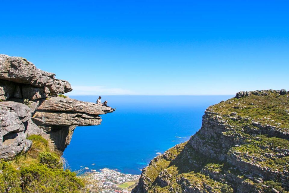
4) From the top of Kasteelspoort to the ‘Diving Board’ (10–20 minutes)
• At the top, pause to enjoy the viewpoint and old cableway ruin remains nearby (once used to build the mountain reservoirs).
• For the Diving Board: follow the clear path trending left (south) along the edge for roughly 5–10 minutes. Small cairns and footpaths lead to a promontory where a flat tongue of rock juts out over Atlantic views. There are a few look‑alike ledges—only one is the famous “Board.” If in doubt, enjoy the safer viewpoints rather than hunting exposed edges.
5) Optional: continue to the Upper…