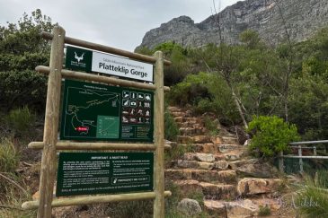
Platteklip Gorge 101: Safely Hiking the Most Direct Route up Table Mountain
Everything you need to summit safely via Platteklip Gorge: where to start, who it suits, when to catch the shade, what to pack, weather checks and riding the cableway down.
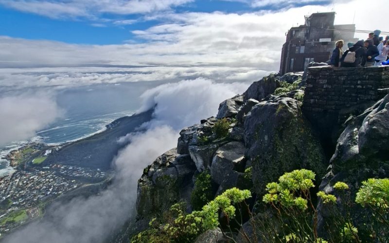
Why Platteklip Gorge is the classic first ascent
Platteklip Gorge is the most direct walking route to the top of Table Mountain. It might be the shortest, but it’s no stroll: you’ll climb roughly 650–700 metres of elevation over about 2.5 kilometres on well‑built stone steps that zigzag through a dramatic sandstone ravine. Most hikers take 2–3 hours to reach the plateau. There’s no technical scrambling, no exposure to sheer drop‑offs if you stick to the path, and no permits or fees required for the trail itself. That’s exactly why locals recommend it to first‑timers who want a clear, straightforward ascent without route‑finding stress.
Direct doesn’t mean easy. Platteklip is a sustained stair-climb with very little respite. The safest and most enjoyable ascents come from realistic pacing, great timing (to avoid heat and wind), and preparing for a mountain that creates its own weather. This guide covers start points, fitness, shade windows by season, the right gear, reading the forecast, and how to cruise back down on the cableway when conditions allow.
Who this route suits (and who should choose differently)
- Fitness profile: If you can climb stairs continuously for 1.5–2 hours with short breathers, Platteklip is within reach. Total time up is usually 2–3 hours; slower parties may take 3.5. Allow extra time for photos and rests.
- First‑time mountain hikers: The path is obvious and well‑maintained from bottom to top. No navigation tricks, no scrambling. It’s steep but simple.
- Families with active teens: Strong, motivated teens generally do fine. For younger children or anyone heat‑sensitive, start at dawn in summer and build in generous rest stops.
- If you have knee or balance issues: The uniform stone steps are reliable but relentless. Trekking poles help both up and down. If in doubt, consider the cableway both ways or hire a qualified guide.
- Vertigo: While you’re walking inside a gorge with big cliffs around you, the route itself doesn’t run along airy drop‑offs. Most people with mild height sensitivity are comfortable on Platteklip.
If you want a quieter, more varied hike with forest shade, consider Skeleton Gorge from Kirstenbosch (longer and more technical). If you want airy scrambles and epic ledges, India Venster is superb but includes exposed sections best tackled with a guide. Platteklip remains the most forgiving for first‑timers who simply want to summit safely.
Exactly where the trail starts (and how to get there)
- Primary trailhead: The Platteklip Gorge trail begins on Tafelberg Road at a signed “Platteklip Gorge” parking area. You’ll see a clear stone path heading uphill to meet the Contour Path after a few minutes, then the main gorge steps above.
- From the cableway lower station: If you’re dropped at the Lower Cable Station, you can walk east along Tafelberg Road to the Platteklip trailhead in about 15–25 minutes depending on pace. It’s a pleasant warm‑up with sweeping city views.
- Getting there by car or ride‑hail: Rideshare drop‑off at “Platteklip Gorge trailhead, Tafelberg Road” is easiest. If you drive, arrive early; roadside parking fills quickly on clear days and can be windy. Avoid leaving valuables in vehicles.
- Public transport: Services vary over time; the simplest approach is a short ride‑hail from the city bowl or Waterfront.
Tip: On extremely busy days or during events, sections of Tafelberg Road can close or become congested. Starting early (or catching sunrise) neatly avoids that crunch.
When to start for the best shade, light and wind
Table Mountain’s microclimate matters more than the city forecast. For comfort and safety, plan your start time around heat, wind, and the gorge’s shade.
- Summer (Nov–Mar): Start at sunrise. The gorge holds partial shade early, but as the sun rises higher the heat reflects off the rock. A dawn start means cooler air, gentler UV, and fewer crowds. Late afternoon can bring shade back into the upper gorge, but summer afternoons are also when strong southeasterly winds are most likely and the cableway often suspends operations—so only choose a late start if you’re happy to walk down and you carry headlamps.
- Shoulder seasons (Apr–May, Sep–Oct): Mornings are ideal and cooler. You can start slightly later (7:30–9:00) and still enjoy manageable temperatures. Winds are variable; always check the live cableway status before banking on a ride down.
- Winter (Jun–Aug): Cooler air and lower sun angles mean more comfortable climbs even mid‑morning, but cold fronts bring rain, slick rock and cloud (the famous “tablecloth”). Pick clear, wind‑light days and pack proper layers. Start mid‑morning to let any overnight moisture evaporate.
Rule of thumb: If forecast maximum in the city is above ~28–30°C and there’s little wind, Platteklip will feel like an oven by late morning. Start early or pick another day.
What the route actually feels like (milestones and pacing)
- Warm‑up to Contour Path: From the roadside, a firm stone path climbs steadily for 10–15 minutes to the Contour Path junction. Turn up into the gorge; signage is obvious.
- Lower gorge steps: The path steepens into long stair‑like switchbacks. Views over the City Bowl and Table Bay open up behind you. Pace yourself—this is where most people go out too hard.
- Mid‑gorge benches and breezes: About halfway, you’ll find flattish spots on big boulders and a subtle narrowing in the ravine. Cool breezes sometimes funnel through here. Snack, sip, and check how everyone’s feeling.
- Upper gorge squeeze: The final zigzags are the steepest and can feel never‑ending. Keep steps short and steady; poles help. The walls close in, then suddenly the path tops out onto the plateau between lichen‑splashed rocks.
- On the plateau: Take a minute to layer up—winds can be surprisingly cold. For the cableway, turn right (west) and follow well‑trodden paths and directional signs for about 15–25 minutes to reach the Upper Cable Station. For the true high point, turn left (east) across the boardwalks and yellow footprint waymarks to Maclear’s Beacon (about 45–60 minutes each way), then return to the cableway if it’s running.
Typical ascent times: strong hikers 1.5–2 hours; average parties 2–3 hours; relaxed or photo‑heavy climbs 3–3.5 hours. Add plateau walking time if you plan to explore before riding down.
Essential gear for a safe, comfortable climb
- Footwear: Sturdy trail shoes or hiking boots with grippy soles. Avoid slick road‑running shoes.
- Water: 2–3 litres per person in summer; 1.5–2 litres in cooler months. Streams are not dependable or treated—assume no refills until the top station café.
- Sun protection: Broad‑brimmed hat, high‑SPF sunscreen, sunglasses. UV is fierce even in wind or cool air.
- Layers: A light wicking tee, a warm mid‑layer, and a windproof shell. The top can be 5–10°C cooler with gusts.
- Hands and knees helpers: Trekking poles take strain off quads and knees, especially if you end up walking down.
- Food: Salty snacks, fruit, and something you’ll want to eat even if you’re a bit tired. Small, regular bites beat one big stop.
- Navigation and comms: Fully charged phone, offline maps, and a small power bank. Reception is usually decent but don’t rely on it.
- Light: Headlamp if starting before sunrise or if there’s any chance you’ll finish near dusk.
- Small first‑aid essentials: Blister plasters, a few bandages, pain relief, and an emergency space blanket (light yet invaluable in wind‑chill).
Weather and cableway checks that actually matter
Table Mountain often ignores the city’s forecast. Use multiple cues:
- Cloud: If the “tablecloth” is pouring over the front of the mountain, visibility in Platteklip can drop and rock gets slick. It’s still hikeable for experienced parties with proper layers, but first‑timers are better off waiting for a clear window.
- Wind: The cableway typically suspends operations in strong winds, sometimes with little notice. Even if you plan to ride down, you must be ready to walk back via Platteklip if the cable cars stop. If summit winds are forecast to be strong or gusty, assume self‑reliance.
- Temperature: Hot days magnify heat stress in the gorge. Don’t be shy about turning around early if anyone feels off—there’s no shame in a safe call.
What to check on the day:
- The official Table Mountain Aerial Cableway status for current operations and last‑car times.
- A mountain‑specific forecast that shows wind on the summit, not just in the city bowl.
Emergency tip: In South Africa, dial 112 from any mobile for emergency services. Save that number before you set off.
Using the cableway to come back down
Many hikers choose the “up on foot, down by cable car” combo. Here’s how to make it smooth:
- From the top of Platteklip, turn right (west) and follow signs to the Upper Cable Station (15–25 minutes on mostly flat paths and boardwalks). Keep an eye out for slippery patches if the cloud has been sitting.
- Tickets: One‑way down tickets can be purchased at the Upper Cable Station (subject to operations and capacity). Prices and last‑car times vary by season and weather; check the live status the morning of your hike.
- Queues: On perfect days, expect a wait. Put on that wind layer before you join the line—the station can be much colder than the gorge.
- If the cableway is closed: Your quickest on‑foot descent is back down Platteklip. It’s tough on knees but straightforward. Allow 1.5–2.5 hours down, use poles, and watch your footing on worn steps.
Safety, etiquette and Leave No Trace on Platteklip
- Hike in a small group when possible. The trail is popular, but solo hikers should still start during busier hours and stick to the main path.
- Stay on the built steps. Shortcuts damage fragile fynbos and increase erosion.
- Hydrate and nibble regularly. Heat stress sneaks up in the gorge.
- Manage expectations in your group. Agree on turnaround times (for example, if you’re not at the top after 3 hours, you’ll reassess).
- Pack out everything. There are no bins on the trail and the raven residents will scatter any left food.
- Be weather‑proud, not weather‑brave. If cloud or wind worsens, take the conservative option.
Sample schedules that work in each season
- High summer sunrise push
- 05:30 Start hiking from Tafelberg Road in cool air, mostly shaded lower gorge
- 07:30–08:00 Top out; add a warm layer
- 08:45 Stroll into the Upper Station; ride down before queues build
- Shoulder season easy‑morning
- 07:30 Park/warm‑up walk from Lower Cable Station
- 10:00 Summit; explore plateau in gentle temps
- 11:00–12:00 Cableway down, beat afternoon wind
- Winter clear‑day window
- 09:00 Start (after checking no rain/wind on the summit)
- 11:30–12:00 Top out; layer up against chill; hot drink at café
- 12:30–13:00 Ride down before afternoon cloud rolls in
Where to stay for an early start (and enviable mountain views)
Base yourself close to the mountain or with an open sightline to Table Mountain so you can read the cloud and wind at a glance.
- For a quick pre‑dawn ride to Tafelberg Road and easy access to the Waterfront afterward: Walk to the V&A Waterfront from a Charming Apartment is an ideal city pad for beating the morning rush and celebrating your summit with dinner by the harbour.
- For postcard‑perfect mountain watching from your balcony (great for spotting the “tablecloth” before you commit): Postcard Views of Table Mountain. Generator for elevator. offers sweeping views across Table Bay—wake up, check the summit, then decide if it’s a hiking or a beach day.
- Prefer to pair your hike with sunsets over the Atlantic? Amazing Ocean Views from Every Room. gives you big‑sky horizons and an easy drive into the city for your early start.
Each is a fully equipped self‑catering base—stock the fridge, prep your trail snacks the night before, and roll out before dawn with coffee in hand.
Frequently asked practical questions
- Do I need a permit? No. Platteklip Gorge requires no permit or entry fee. Parking along Tafelberg Road is free but limited.
- How long does it take? Most hikers summit in 2–3 hours. Strong hikers may be faster; always allow buffer time for exploring the plateau and potential cableway queues.
- Is there shade? Portions of the gorge are shaded early and late, but expect long stretches in full sun, especially mid‑morning to midday in summer.
- Is there water on the trail? Streams are unreliable and untreated. Carry all you need; you can buy refreshments at the Upper Cable Station when open.
- Can I hike down a different way? Yes, but for a simple, fast descent if the cableway is closed, Platteklip back down is best for first‑timers.
- What about security? The route is busy in daylight and generally feels safe, but use normal urban‑mountain sense: hike in a small group if you can, keep valuables tucked away, and avoid starting or finishing in the dark if alone.
A conservative plan that keeps you safe
- Night‑before checklist: Check the cableway’s planned opening time and live status, and a summit‑level wind forecast. Lay out water, layers, snacks, hat and poles. Set a turnaround time based on your group’s slowest member.
- Morning of: Recheck the wind and cloud. If a tablecloth is forming fast or winds are ramping up, switch to a city or beach plan—you’ll get a better day on the mountain soon enough.
- On the climb: Sip often, snack early, and keep conversation going; quiet hikers are sometimes struggling. Stop to cool down before you’re overheated.
- On the plateau: Layer up before you chill, check cableway status screens, and head for the station. If the cars stop, decide whether to wait (they sometimes reopen) or descend on foot with fresh legs.
Platteklip rewards patience, pacing and preparation. Choose your weather window, start early, carry the right kit, and leave enough energy to enjoy the views from the top. Whether you step into a gently rotating cable car for a fast glide back to the city or stroll down the same steps with a grin and tired legs, you’ll have earned every metre of Cape Town’s signature summit.